Waterways have an inherent sense of story—they bring elsewhere to you, following a path with a volition beyond your own, and tacitly invite you to find out where from and where to. Here’s one: Hobson’s Conduit, a stream dug in 1610 from chalk springs out in the fields to the heart of Cambridge, still flowing and steeped in city lore. When a retired Cambridge professor told me about the walk along the Conduit’s length from city center to source at Nine Wells Nature Reserve, I tucked the captivating idea away in my to-walk list. Although I inadvertently walked partway on the inviting public footpath once, it took me a while to pick up the trail again.
Boxing Day 2020: gray and brisk but not raining or freezing; paths still muddy and fields flooded after the storm two days before Christmas. Looking for a way to pass an afternoon with a friend on the first day of renewed Covid lockdown, I suggested the walk to Nine Wells.

This was an imperfect pilgrimage, if that’s what it was. We picked up the trail where the nice footpath starts at Empty Common Community Garden, bypassing the concrete channel down the street which leads to an elaborate monument before filtering underground. I had noticed in the past little tributes to the disappeared conduit, plaques in the concrete under my feet, elsewhere in Cambridge. We didn’t go seek those out, or the sluices on either side of Trumpington Street where that branch of the conduit is let into the open before ending in college ponds.

The Empty Common Community Garden was in winter dormancy, and we were glad for our wellies in the squelchy mud of the path. Hobson’s Conduit itself was tranquil between its banks, not flooding like other local brooks recently had. In fact, it was rather unremarkable, slightly stagnant, the color of bare branches, gray sky, and murky sand. When we reached the open field at the end of the Empty Common section of the path, it became clear that there was no way to keep following the brook on the other side of the A-road that hemmed the field. Although there was one of the Hobson’s Conduit Trust commemorative banners pinned to the fence announcing Hobson’s Conduit, Cambridge’s unique watercourse, the crossroads into the housing development was blocked. Instead we were shunted through an underpass, vibrant with graffiti, and along the guided busway with its concrete tracks into the chimeric nature-industrial hinterland of south Cambridge and Trumpington.
Here, between the guided busway and train tracks running alongside the Cambridge Biomedical Campus (home of Addenbrooke’s Hospital), and the burgeoning development of Trumpington, is an open green, a scrubby wetland with the distinct look of a recently reclaimed nature reserve: miniature groves of small trees and shrubs with protective cylinders of netting, pristine gravel paths, strategically placed ponds with bulrushes for waterfowl. Open and winter-dull as the wetland was, it was impossible to disassociate it from the endless rowhouses on one side, the hulking high-tech buildings of the Biomedical campus on the other, and another heavily tagged overpass ahead. Its expansiveness, however, and the noisy presence of birds on the water, kept it from feeling altogether fake. It had a haunting, almost bleak sense of modified wildness, holding its space open out here on the margins. It lends a bleak beauty to the buildings, too. I’ll be interested to come back in a friendlier season, with binoculars for the birds.

Biomedical Campus 

Pond and Trumpington
Almost to Nine Wells—we cloverleafed along the pedestrian access to the overpass to get across the train tracks, skimming the edge of the empty Biomedical Campus and then back under the road. I felt the shift to true countryside, the familiar pattern of fallow fields and windbreaks. We soon reunited with Hobson’s Brook where it crossed under our path, gleaming dully, running out from the line of trees demarcating Nine Wells LNR and away under a graffitied bridge. We followed it in.


The rectangular patch of trees is the smallest reserve I’ve seen yet in Cambridge. It’s just wide enough to hug the chalky string of spring heads (I saw four on the map, not nine). We looped around the rectangle, finding the scoops that dug into the banks with no clear emergence point for the water, which must seep diffusely through the chalk. The channel the springs feed was still; the bed was thick with beech leaves coated in chalk, giving it a pewter look under the dark glass of the water. The more thickly coated spots reminded me of Yellowstone hot springs blanketed with calcite. One small muddy scramble gave our boots a nice coating of creamy chalk mud.


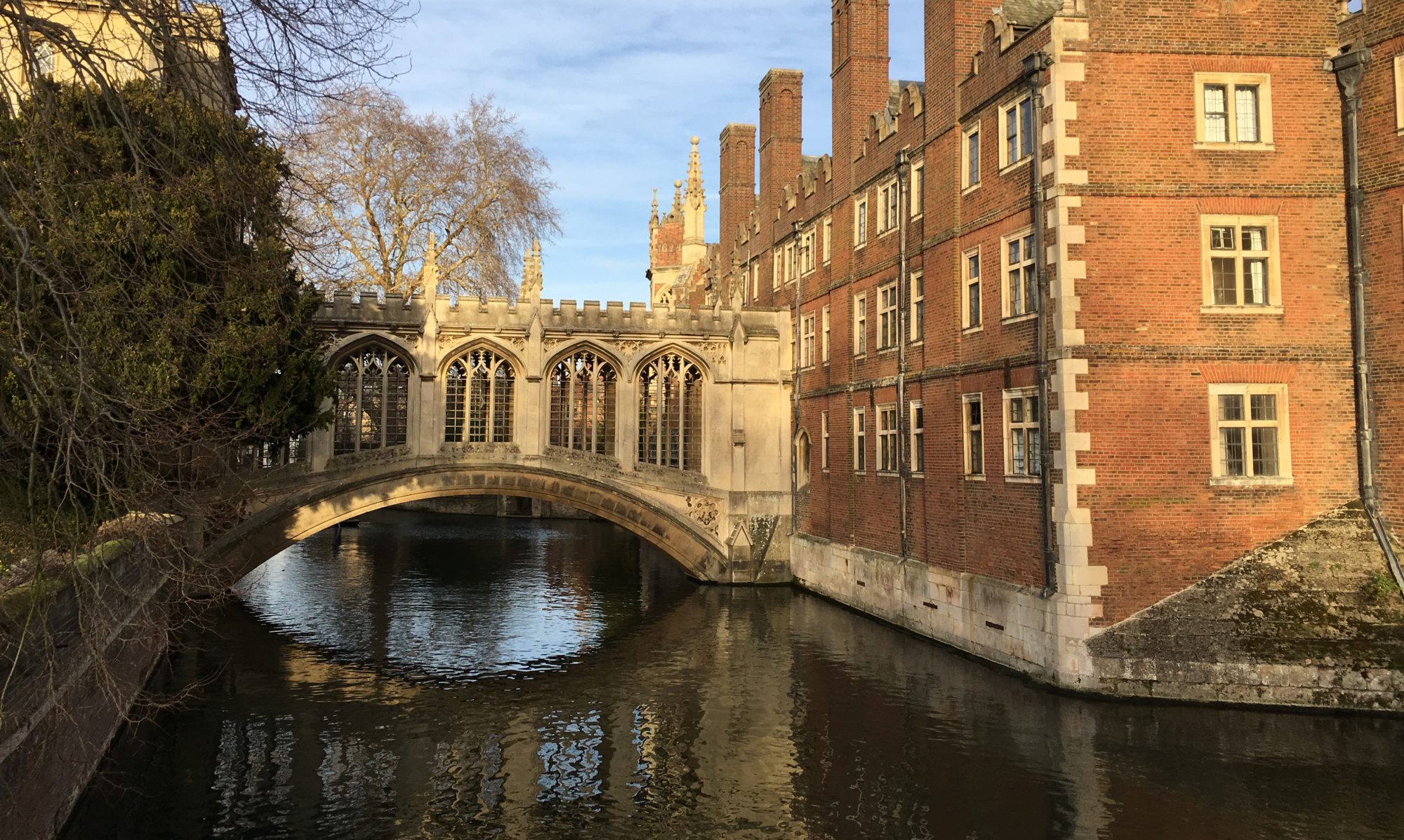
At one end of the reserve is an obelisk installed in the 1800s to commemorate the conduit and its titular benefactor, Thomas Hobson, in similar spirit to the monument we skipped on Lensfield Road (part of the original Market Square fountain, moved there in the mid-1800s). Why so much civic pride about this little canal? In the 1600s, when it was dug to flush disease-ridden sewage out of other ditches and then became main source of drinking water in Cambridge, perhaps it was a major gamechanger (though I read that it didn’t succeed in flushing out the ditches). Perhaps the monuments arose from a sense of gratitude, some version of the wonder we may feel at the gift of fresh water issuing unbidden from the earth. I get the feeling, however, these commemorations are more about the engineering, the upstanding citizen and community builder the Victorians saw in the 17th-century philanthropist. They speak, too, to a time when Cambridge was small enough and humans’ power over the landscape limited enough that a canal like this would not be easily forgotten.


What about now, with the banners and plaques? The conduit is no longer a source of drinking water, though it is tapped for irrigation. Climate change and droughts threaten its continuance regularly. The reserve lost its status as “Site of Special Scientific Interest” in 1976 when the rare invertebrates dried up (though it’s apparently being managed to restore them). The conduit has become so full of silt that last summer the Hobson’s Conduit Trust borrowed some heavy machinery to dredge the bottom so it could still flow. It feels a little forlorn, like something dusty and overshadowed that the local guardians of history are giving a last-ditch effort to bring into public remembrance, but which may not keep its identity much longer.
But maybe it will. I still feel the pull of these traces of history, this physical story. I’m not the only one, clearly. What drives this feeling?
I’m accustomed to finding enchantment in a waterway’s story primarily because nature shaped it. In the case of Hobson’s Conduit, however, I need a broader perspective. The springs at Nine Wells, as closely contained and well-trodden as they are, still have the charm of “real” nature. The mystery of the water, still emerging from the chalk despite all other changes to the landscape, seems to justify the little shrine of trees. But when looking downstream from this place, I found the Conduit itself disappointing. Despite the lessons Cambridge has been teaching me about the falseness of the dichotomy between natural and modified landscape, my deep-seated craving for the “otherness” of nature, tickled by the springs, also sets me up to discount the stagnant, eventually concrete-lined channel that they feed. Of course, if I looked closer—if I participated, for example, in the Hobson’s Conduit Trust “Bioblitz” they conduct every year to document the biodiversity it supports—I would no doubt see it differently. Nature always has some story to tell, even in collaboration.
But the waterway, the course, the flowing, relies on history for its full power as a story. I can walk through Cambridge and see bricks and stone laid in the same century that this channel was dug. Those buildings tend to be more eloquent, to varying degrees, and to demand more attention. But this little canal, written into the landscape by people, also made life better for the overcrowded townspeople hemmed in by those college buildings. The water from the chalk of Nine Wells became part of the story of the Market Square, where the fountain of clean water made a new heart for the city. And that’s only one layer.

Trumpington Rd 
Lensfield Rd monument 
Facing Trumpington Rd 
Trumpington St culvert 
St. Andrew’s St 
St. Andrew’s St
There’s something about reading this story by walking along it—to the source, where the whims of the earth are still filling the channel that people with motives we understand dug into the earth and brought a new story into being. And to the sink—I went today to find the monument at the Conduit Head, and to follow the accounts of where the water still goes along the lay of those actual streets—the culverts on Trumpington, which are empty for the winter but are still enchantingly named “Pem” and “Pot”; the now-dry fountain in the middle of market square[1]; and the paved-over course along St. Andrew’s Street where the plaques quietly remind pedestrians who care to look that this was not always a shopping mall, and history is still flowing along its course.
The story keeps going as long as the water is flowing, or failing that, as long as people keep telling it.
[1] Which is actually currently barricaded due to Covid restrictions, apparently for the first time in history.
This was really fun to read, Anne! I’m glad you included the map at the end so that we could picture, in another way, where your walk took you. I bet there are not many people who know or care or take the time to follow this path, so that’s nice that you did!
This reminds me so much of an episode of “In the Americas”, with David Yetman, that I watched just a few days ago. It’s a PBS show that has a very real and personal feel, even though their budget doesn’t approach some of the other nature/culture/history/geography programs out there. As the title suggests, the scope of the show is the entire western hemisphere, but I’m sure that the author/host is partial to Central and S. America.
ANYway, he did this one on the central importance of the waterways that gave rise to Mexico City, 500 yrs. ago, and really, 500 years before that. Because the city began on an extensive lake and wetland, there is an incredibly long and complex history as to how the growing city gradually transformed the whole ecosystem of the valley, and of how the use and management of the water changed over time. And just like the long story of Hobson’s Conduit, it’s really an ongoing tale, and one that is well below most folks radar.
I’m so glad that you are able to identify and pursue these hidden stories. It’s a talent that will serve you well in your work and general qualifications as a citizen of the world.
Just a footnote; I had to pause and consider when I got to the idea that a man-modified environment is part of the larger whole of earth habitat. I think I understand the intention behind the sentiment, but like you, I don’t think it has a lot to recommend it. Too bad we are such tiny drops in the ocean of history and humanity. We do our best.
Very interesting, thanks for sharing!
And thank you!
Re man-modified environments, it’s a tricky philosophical balancing act, because while landscapes without humans have a complexity and beauty that simultaneously put us in our place and tend to persist better without us, the fact is that we have modified virtually the entire earth. So I’ve found that there’s a need to both celebrate the nature that exists even in conjunction with us–as part of nature ourselves, and so that we don’t end up rejecting huge swaths of earth as nature due to our presence there–and also not to become complacent about what our changes do to diminish it. This is especially poignant in a place like England, where humans have occupied every inch in some way for millenia, where for example sheep have arguably become part of the native wildflower meadow ecosystems. There have absolutely been landscapes lost–forests, for example–and there are much-debated proposals about rewilding. We’ll have to talk more about it sometime, it’s such a fascinating question!
A delightful story about a sad little ditch! For some reason, your description of this ditch and it’s environs reminds me of the forlorn, dusty descriptions of Witch Finder Pulsifer in “Good Omens,” and his continuing relentless pursuit of witches even to the present day. (I had to use quotation marks because I don’t know how to italicize things on my iPad. Forgive me.)
Will you turn your blog into a book for naturalists some day? I’ll buy a copy!
Haha, interesting! I hope I didn’t paint it as TOO forlorn. It’s still a cool stream.
That is my dream, Al! I will put you on the preorder list 😉
I love how your eloquent writing illustrates your unique experiences. Then, your beautiful photography comprehensively enhances my meager attempt to picture all that you describe! Thank you, Anne. Your posts are absolute therapy for my soul and compliment my love of nature.
Thank you Tonya! I’m so glad to hear that! <3