I have an elderly friend from church who I’ll call M. We bonded over classical music soon after I moved in, and our friendship was sealed when she invited me to come with her to hear Joshua Bell play in Wigmore Hall, her favorite concert venue in London. After the pandemic had kept me away for some time, she asked me to come visit her. She lives alone in a sunny semi-detached house in Longstanton, one of the many medieval villages orbiting Cambridge. Visiting her would entail a long cycle or a longer bus ride; I didn’t hesitate to choose the cycle route, not least for its tour of the countryside northwest of Cambridge. I’ve visited her several times now, thoroughly enjoying the ride, her company, and the stories gleaned from both.

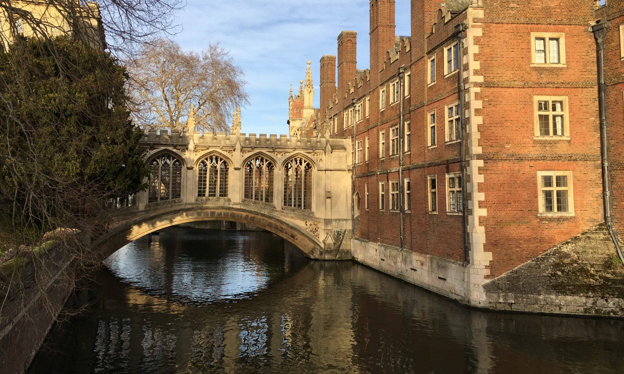
Here’s the route, a six-mile spoke out from the center of Cambridge, strung with villages like beads. I delay my entry onto the long, busy incline of Huntingdon Road by long-cutting through the colleges on Storey’s Way, the same route I take to get to the Ascension Parish Burial Ground. I go as far as skirting around the field beyond the burial ground, almost to Eddington, until I have to turn onto the chestnut-lined lane that in summer is a full-crowned tunnel of green, but in winter is starkly bare, though full of birds (a wren quick across my path, a thrush in the thorns, a magpie flashing in the field). Then I’m on Huntingdon Road, which at least has the charm of being the route of an ancient Roman Road, the Via Devana, which ran from Colchester in the southeast of England to Chester in the northwest. But I’m not going to Huntingdon; I turn off at the village of Girton, the first in the string. Girton College, the first Cambridge women’s college (preceding Newnham by a few years, though now coed), is shrouded in woods to the left, but I don’t have time to stop and wander the Mare’s Run (for another post).

The road I’m following now, the string through the villages, shapeshifts between the High Street of the current village and the road pointing to the closest neighboring village. It’s Girton Road as I leave Cambridge, Cambridge Road once I’m within Girton proper, and Oakington Road after I pass through the opposite end of the High Street and am on the way out of Girton. Girton is sizeable, subdivisions spread along this string for over a mile, cross-sectioned in the middle by the A14 highway (which shortly joins Huntingdon Road to follow the Via Devana out of Cambridge). At a bend near the historic center of Girton is a well-kept medieval church, St. Andrew, where I paused once to admire the array of headstones and modern wire sculptures.


Now, out of Girton, a fresh new cycle path alongside the narrow road through a stretch of countryside. Cycling is better than driving for seeing the countryside, but it’s still not as good as walking; my eyes have to spend too much time on the road. I only get stolen glimpses of the passing lanes curving away alongside flowing ditches, the light on the whitewashed cottage walls, the hidden garden gates, the woman tending to shaggy Shetland ponies in the pasture, the pheasants hunched in the field, the picturesque pubs, the red telephone boxes converted to little libraries and greenhouses.
Oakington blips by in only a few curves. The road, now dubbed Longstanton Rd, gets rougher as it heads back out into fields, narrow, shoulderless, grass and nettles encroaching along cracks in the asphalt. Soon there’s a barrier. The first time I took this route, I saw the crumbling industrial concrete wall across the road and thought Google Maps had led me astray into road construction (on a road that sorely needed it)—and that I would be very late to my lunch with M, as this was the only remotely direct route between Oakington and Longstanton. As it turned out, the barrier was porous, allowing pedestrians, cyclists, and equestrians (with the horse droppings to prove it) to weave through, but no motor vehicles. And the cracks in the road were not being repaired.


The clear abandonment of the road, though tempered by birdsong and the cheerful gait of dog-walkers, hinted at a story. For how long had the speed limit signs been peeling and the trees arcing ever thicker over the road? There were open, wild-edged fields stretching away on one side, birds in the brambles, but what were the trees screening on the other side? The road took on a different tinge of eeriness when I came upon a true construction site, a wide, flat road crossing this one and curving away through the fields via an empty roundabout, silent and new. In the distance was the white glint of a suspension bridge over some major road. Only a year later did I cross this junction with any sign of life: trucks rumbling on the other side of the strip of private wood and a sandwich-eating construction worker vaguely managing the crossing. Clearly, out of one story, another is being written. It took M and a bird’s eye view to start filling in the gaps.


M lives quite close to the edge of Longstanton, near the emergence of the old Longstanton road from the thickets. Her development, called Thatcher’s Wood, is indeed ringed nicely in old trees, with views out into green fields down the handful of parallel streets that have otherwise hollowed out the one-time Wood it’s named for. She hasn’t lived there long by the scale of her life; a decade or two. But she’s paid attention to the place, and has plenty of stories to tell.

Whenever I visit, we sit at her kitchen table striped by midday sun and chat and have a simple lunch. Her bird-call clock usually cuckoos a few times before I leave. It isn’t difficult to fill those hours, because, as I said, M is a storyteller. Her mind is sharp, and her keen delight in her observations of the people she encounters and the quirky details and funny coincidences of her daily life is contagious. Maybe it’s her quiet confidence, her intelligent engagement with the story, her liberality with chuckles at her own humor; you can’t help but absorb the same regard for her telling. She seems to dip into memories from any period of her life with ease. As I listen, I sometimes feel like a detective threading string between pins on a pinboard, but she always has a grasp on the thread.
M almost didn’t go to university, she tells me; was enrolled in a teacher training school, but one of her teachers said, why not go to university? She was one of the few maths students at her school, but the best. She went to university and became a maths tutor. She might have studied languages, has always liked them (and now studying on DuoLingo is one of her pastimes), but people who studied languages had to have money to travel, for their year abroad. She never did travel until much later, not because she didn’t want to, but due to circumstances. They would camp instead. There was one place on the coast of Wales, a cliff with such a stunning view…and one of the last trips she went on before she and her husband were too old, it was so dark when they woke up in the night that the stars were like nothing she had ever seen, like they always say, the sky like velvet and diamonds, and she had even lived through the blackouts during the war.


Besides the aches and pains of age, M’s main limitation on her independence is her rapidly failing vision. She could see that I was there, she said while sitting across the table, but couldn’t make out my face (and at church I have to speak for her to know it’s me coming to say hi). Yet she knew when the neighbors’ cats were sitting expectantly outside the sliding door, and she could potter around the kitchen seemingly without much trouble, putting away dishes and heating up soup and making an omelet for our lunch. She eventually let in the Siamese cat, who leapt happily onto her lap and whom she gave a thorough, familiar rubbing. It’s easy to forget that her visual experience is so impoverished.


The first time I visited, her vision hadn’t deteriorated so far, and her stamina was enough to take me on a walking tour of lower Longstanton. Here was laid the oldest tangible layer of stories in the form of two medieval churches. Longstanton’s identity stretches back at least to William the Conqueror’s Domesday Book, the census of land taken in 1086, when there were actually two villages (hence the two churches) known by roughly the same name. These churches have traces of architecture from the centuries soon after that. Not far from M’s house and the emergence of Longstanton Road is the atmospheric crumbling old St. Michaels Church, thoroughly quaint with a thatched roof (rare for a church) sloping steeply almost to the ground. Among the weathered headstones in the churchyard is a covered well with steps leading down inside and ferns growing out of it and a sign explaining it was once used for baptisms. The church is disused—its parish was merged with the other church’s parish in 1953—but not deconsecrated. We went inside (careful, she said, the latch sometimes gets stuck so you can’t open it again from the outside, I’ve told them about this) to see the bare pews and simple altar and wooden ceiling.


M was never Anglican; she was raised in the Church of Jesus Christ of Latter-day Saints, one of the few in England at the time, and recently celebrated the 80th anniversary of her baptism. As a little girl, M loved church, where people told stories and sang. Her father became a local leader, and she spent a lot of time waiting after church in the meetinghouse, picking out hymns on the piano. Now she’s the music coordinator in our congregation.
As we made our way through Longstanton to the other medieval church, M also had stories for the nearby houses, pointing out which ones had sprung up since she moved in, and which were much older, including a house with a courtyard that she said was probably a farmhouse, with the neighboring thatch-roofed Tudor-style worker’s cottages now joined up and expanded.

All Saints’ Church is at the crossroads of the main throughlines in the attenuated village plan, where its spire stands out handsomely. We couldn’t go inside, so missed seeing the tomb of 17th-century village bigwigs, Sir Thomas and Lady Hatton, in their family vault. The Hatton name came up several times when I perused the internet about Longstanton history; it’s strange to think that wealthy landowners had their seats of power in such obscure places. We walked around the well-populated churchyard while a rookery in the big bare trees made a racket and M mused about the waste of all the young men killed in the wars, a good number buried here with uniform white marble headstones. (The reason for this is coming up…)


M didn’t have many close family members who fought in the war; her parents were on the older end and her father’s siblings had moved to the US in the 1920s. But she remembers the war, living under ration; she didn’t have cream until she was in her 20s—maybe that’s why she loves it so much now. Same with chicken, perhaps because they were in the city. But it was just normal life for them.
World War II also transformed Longstanton history, and here is where we begin to get answers to the story of Longstanton Road. On the other side of those mysterious trees along the road? A defunct airfield. Longstanton swelled when RAF Oakington (a Royal Air Force base) opened in 1939 (with more infrastructure around Longstanton than Oakington despite the name). That was when the Longstanton Road closed; it’s been languishing for eighty years. M told me her house was built as part of a barracks, while the nice big brick houses down the road were married officers’ houses. The airfield was only in use as a flying training school until the 70s, when it became an Army barracks until the 90s, and then it was an Immigration Detention Center until 2010 (I wonder what that was like).

The rumbling trucks behind the trees? This is the latest reimagining of the old RAF base, as a whole new town, Northstowe—one of many new developments popping up Cambridgeshire. I supplemented M’s tale with Google Maps and was rather shocked by the size of the foundations of the new town engulfing ancient Longstanton along its northern and eastern flanks, filling the space between Longstanton and Oakington. Most of the old site is still cross-hatched with old airstrips on the latest satellite image, but the northern end has subdivisions and an elementary school called “Pathfinder C of E School” after the Pathfinder squadrons who marked targets for bombers. The development’s website pays homage to this history as well, including striking photos of the abandoned base.

And the new roads I saw stretching away from my crumbling thoroughfare? Roads to service the future Northstowe, mapping out to other recently constructed towns like Bar Hill. M also told me about the convoluted history of thoroughfares connecting and disconnecting Longstanton from the surrounding towns—without that old linking road, it’s impossible to get to Longstanton as directly from Cambridge by car as it is by bike. The village has also lost traffic since the A14—the Roman road, remember?—was upgraded. There’s also the guided busway—the longest in Europe—angling past nearby, once a railway line with a Longstanton station. That was closed in 1970 after over 100 years, like many other rail lines in Britain mourned in a classic song, Slow Train: “At Long Stanton I’ll stand well clear of the doors no more…” (Incidentially, I owe a blog post to a long cycle along this railway-turned-busway to St. Ives. “From Selby to Goole, from St Erth to St Ives, they’ve all passed out of our lives…”)
On my way out of Longstanton after my first visit to M, my eye was caught by a signpost pointing perpendicularly out of the village, labelled “Public bridleway.” Intrigued, I followed the lane past rural houses until concrete crumbled into dirt and the edges became fields. After juddering along the dirt path for a little while and stopping once to read a rather unexpected and weatherworn interpretive sign about roads in Cambridgeshire (e.g. the Via Devana), I came across an alien-looking concrete contraption like a large upside-down bowl on a pedestal by the side of the lane. There was no interpretive sign for this, and at the time I still only had a few pins in my pinboard of Longstanton history, so I had no idea what to make of it. With the military context, the answer makes sense: it’s a pillbox, or anti-tank gun shelter (specifically a cantilevered pillbox, a rare and much different design from the square shell I saw at Ascension Parish Burial Ground).


It makes me wonder–if a bird’s-eye-view timelapse of Longstanton for the last 1000 years were possible, would the changes M has seen within a few decades of living here rewrite the place in the blink of an eye? In another 80 years, will these fields still have traces of their brief but transformative military past? After more than a millennium of Longstanton nestled in its arable land, will these fields even remain?

I really enjoyed this Anne (not least the vibrant greenery),(and the cats). M. sounds like a friendly and fascinating person. Old people can be so rich and storied, as you say. As I saw the first few pictures of your bicycle route to Longstanton I was astonished (again) at how much rural land remains, at least in the blogs you’ve shown. But later in the account I was brought down to the more familiar reality of development poised to outstrip anything ever imagined. We do now to the landscape in 10 years what literally used to take hundreds! Cambridge area (and Europe in general) has such collosal history! The world is spinning faster now…
Agreed!
Thank you, Anne. My thoughts echo Karl’s almost exactly. It occurred to me that while I personally cherish the evidence of the ancient past, the fact is that our generation’s construction (which dismays me) is simply more of the same which happened in Longstanton 1,000 years ago. True, our ability to construct entire cities in disruptive and appallingly short lengths of time outstrips the distant past in a logarithmic scale, it still all falls under the heading of development. The distant past construction is imbued with my overlay of romanticism. (However, imagine how unsettling it would be to be baptized in that well…😬…it looks more like the mall entrance to hell.)
Thanks, as always, for your sharing your meanderings! Love, Aunt Al