My favorite way to explore:
- Look at Google Maps on satellite mode
- Find the green patches
- Think about where I haven’t been recently (or ever)
- Click around for general cycling directions
- Get on my bike
- Deviate from that route as much as I like.
On Easter Sunday, a month ago now, my afternoon was wide open after Easter observances and the weather was perfect. So I opened Google Maps and consulted my map feelers—where I felt like being and where I could extend my exploration coverage—and decided on the direction of Jesus Green and Fen Ditton. No endpoint in mind, just a place to be and see where I ended up.
Well, I ended up seven miles down along the River Cam. The pull of the path was irresistible, and only a sense of daylight waning turned me back.

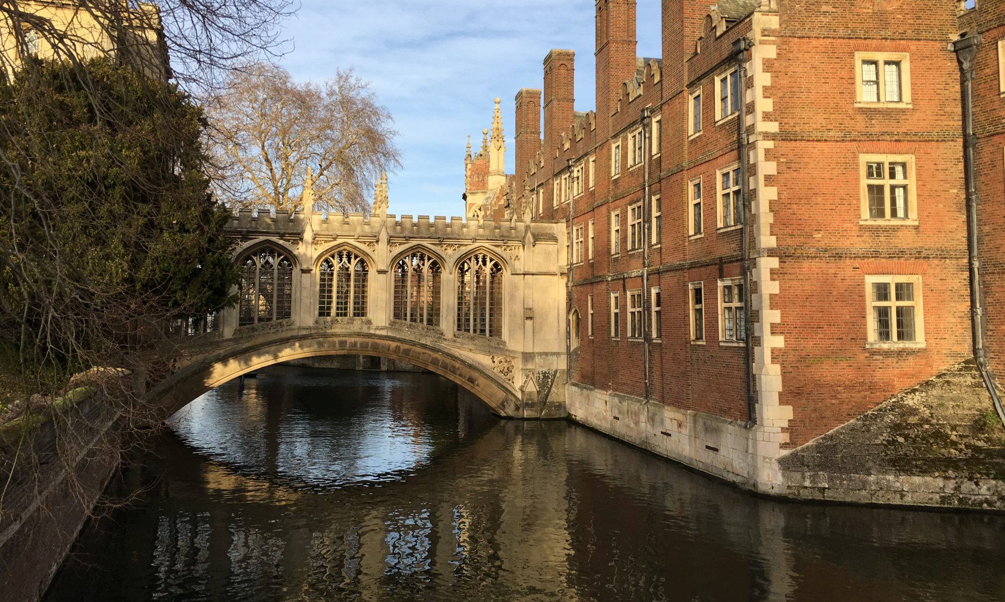
Back to the beginning. The route through Jesus Green and Midsummer Common is familiar—I’ve written about it here. On a sun-touched day like this the greens are arrayed with yet more sunbathers on their small bubbles of lawn. Midsummer Common has cows, a sure mark of spring. This time, however, I don’t pause (for too long) to people-watch (or cow-watch). I keep on going past the houseboats and boathouses and under the bridges, past the smokestack by the Museum of Technology and the sleek Riverside Bridge that splits into curving pedestrian and cycling halves suspended next to each other over the river.
This journey will turn out be one of crisscrossing, chasing navigable paths. Already, though I don’t need to cross yet, this bridge is such a beauty I must cycle halfway over and then coast back down the ramp, pausing first to look down on an inviting little park I didn’t know was there. It’s still too early in my journey to deviate too much, so I don’t stop. I must detour, though, around the road where police taped off piles of scrap metal—mud-colored bike and boat parts, a shopping cart, road signs—that seem to have been recently trawled out of the river.

Jesus Green 
Riverside Bridge 
River junk


Back to the riverside road and to Stourbridge Common, a decision point. Though the bridleway stretching ahead between the river and the Common is busy and inviting, the signs that have been there since my first wander along this path over two years ago, warning of route closure at “the Jetty,” are still up. If I want to get much farther along the river I know I need to cross. But Ditton Meadows, along with Stourbridge Common one of the biggest green patches on the map, is calling to me on this side of the river. So I keep wandering along the river, admiring eccentrically decorated houseboats and sun glinting on the expanse of hummocky grass, all the way to where the signs eventually prove their point: chain-link fences all the way down to the river at the base of the railroad bridge (the Jetty?) on the other side of which another sleek new pedestrian bridge waits quietly, sea-foam green (or is it Cambridge blue?) with curving ribs similar to the Riverside Bridge I so admired. Men in orange suits are surveying along the railroad and signs herald the coming of the new Chisolm Trail connecting various new developments and green spaces, but which has ironically quite choked off pedestrian traffic here for several years of construction. Instead, to reach the idyllic pastures on the other side of the fence, I have to rattle over foot-worn paths of cracked dry mud, smushed tussocks of river grasses, and makeshift plywood crossings over streams and mud pots to the steep, graffiti-smothered step bridge over the railroad tracks to Ditton Meadows.

Stourbridge Common 
Decked out houseboat 
New Abbey-Chesterton bridge from Ditton Meadows


Ditton Meadows and Stourbridge Common are both quieter and more expansive than Jesus Green, but are still a place for people to ramble, soak up sun, and get a little taste of wetland—tall feathered grasses along the ditches, hearty birdsong, little burbling Coldham’s brook heading into the Cam, grass everywhere glistening and lush in the sun. I would pause longer where the brook comes out under the bridge, but it’s not long before people are behind me. The paths lead on into Fen Ditton, a charming village, and even farther on to places like Anglesey Abbey—which was the last destination that brought me this way—but already my thoughts are turning back to the river. When I’ve rested enough to huff back over the bridge with my bike, I trace my path back over the bumpy Common to the last crossing point, Green Dragon Bridge. This narrow bridge over genteel houseboats and the Green Dragon Pub is the gateway to the towpath.

Ditton Meadows 
Ditton Meadows 
View from Green Dragon Bridge


The towpath: a well-packed dirt track hugging the River Cam, leftover from horse-drawn trade boat days, now a place for people—plenty of them today—to stroll. I’ve been on this path once before by accident, intending to find a place to watch a boat race on the Fen Ditton side of the river and being directed by a well-meaning organizer to this side, where the rowing coaches and auxiliaries were cycling alongside and shouting to the rowers. Holding up traffic would not be tolerated. But it was too late to turn back or we would miss the race, so we cycled on through the mud. In the gaps between boats I saw the blue beauty of the river and the green charm of Fen Ditton and wanted to come back on another peaceful day. That turned out to be today.
I retrace the section of towpath I’ve seen before: meadows alternate with well-to-do cottages and beer gardens; houseboats and stately spring-green willows and blooming brush line the banks. The water is sky. People stroll. There are swans and ducks and coots. Fen Ditton’s medieval church tower is square above trees and rooftops. I pass one path leading off between trees called “Grassy Corner” on the map—and marked by a discarded mattress and shopping cart full of rubbish, in contrast with the quaint affluence on the opposite bank—which looks like it may lead to a nice meadow, but I realize it also leads to a trailer park, and don’t want to intrude. I wonder what the river means to the various residents here.

Railway bridge from towpath 
Fen Ditton from towpath 
Fen Ditton church


After this, the last vestiges of Cambridge fall away and the river enters new territory: open fields, idyllic green, gently curving furrows given scope by windbreak tree lines and freestanding brick farmsteads. I can’t get enough of it. I start to get a sense of distance when the river passes under the A14 motorway bridge (interestingly hand-painted blue with “Newnham” in white letters; my college has good success in boat races so I’m guessing this is related), but I keep going. Another stretch of fields brings me to the Baits Bite lock, another milestone. This junction, bridge over the weir and the industrial mechanisms of the lock, is busy with people and kids on bikes; a girl on a houseboat has a puppy. Beyond it the towpath narrows and spools onward, quieter. I’m committed now. I keep going.

A14 bridge 

Baits Bite Lock


Now the riparian brush is thick along the towpath but I spot fields beyond, and in them a slow scattering of roe deer. Short passenger trains are audible and frequent on tracks a field away. Occasionally I pass joggers and picnickers paused on the banks; a couple is cozied in the cradle of the big tree stump (they’re still there when I return). There are more houseboats, colorful and cozy, and another square church tower in the distance—Horningsea village.
A long, long draught of green and blue.


The towpath finally veers away from the river, no longer a towpath, at the dozen-building hamlet of Clayhithe (almost to the town of Waterbeach, which surprises and pleases me with how far I’ve come). I decide to cross the bridge instead, following my nose, and find an interpretive sign inviting me to follow the Fen Rivers Way along the opposite bank. Gateway to the Sea, it declares. The Cam once sent “clay from Clayhithe, eels from Ely, baskets from Fen Ditton, pottery from Horningsea” through the fens out to sea ports. Now it only “carries water from a thousand drainage ditches, working to keep the Fens dry” for the railroads and roads that took over from river transport, the acres of now-arable fields, and the booming, tech-driven development of Cambridge. It only leads fish and birds and humans through the fens and fields seaward. I’ll follow it a little further.
The Fen Rivers Way first passes a sailing club with immaculate lawns and shiny white boat after shiny white boat. This setting is less inspiring to me than the open fields, except that the water has somehow taken on even more of the sky, which has started to paint itself with a stream of cirrus and sun, and anything would be beautiful under this. Then I’m on a bumpy dike with a sweeping view of fields, wilder somehow than the earlier stretch, with banks of wild river grass. The river is wider and I see new birds: crested grebes, a grey wagtail (which is actually yellow). A boy gets scolded by his parents for not being a gentleman and holding the kissing gate when I struggle awkwardly through with my bike.


Soon I reach Bottisham Lock, where this path runs up against a pumping station. If I wanted to ditch my bike and walk to Anglesey Abbey, I could turn onto another grassy dike along Bottisham Lode, an ancient Roman canal cutting perpendicularly through the fields. Or if I cross the bridge over the lock the river-path picks up again, flowing seaward alongside the Cam. The Cam will carry its water to the River Great Ouse south of Ely, where the closed-audience Cambridge-Oxford boat race was taking place just a few hours before, and where eels come from their spawning waters in the Sargasso Sea to mature. The Great Ouse coils on through the fens and into Norfolk and out at the Wash estuary into the North Sea. But it’s getting late; I turn back here.
(I actually do cross the bridge over Bottisham Lock, but only to take a slightly different route back, around the sailing club, through a charming nature reserve called Cow Hollow Wood, back to the towpath at Clayhithe.)

Cow Hollow Wood 
Cow Hollow Wood 
Bottisham lock pumping station and Bottisham Lode


One more deviation: I leave the towpath before Bait’s Bite Lock to go visit a new (for me) green patch, Milton Country Park. It’s a roomy reserve, full of trees and meandering paths, meaning more nose-following to decide which ones to take to find views over the big ponds, which are really old quarries (there are many signs warning about deep, cold water and forbidding swimming). I find a small jetty for an evening meditation. A moorhen nesting in the reeds, greylag geese trailing their wakes to me, squirrel rustling above me, and moment of grace: the kingfisher skimming his jewel blue and flaming orange across the expanse of water like a shooting star that goes and goes longer than you could ever ask.


There is more to explore, but the sun is angling down and I have a long way to cycle still. I take Cycle Route 51 past Cambridge North train station, which is smooth but industrial, eerily quiet, an alien world after the day of green. It feeds me right back to the Green Dragon bridge and the still-busy, post-golden hour Jesus Green. Stiff and sore, I can feel the miles of bumps under my seat and my bike hunch cricking my neck, but also the green and the sun and the blue and the open, trees and boats and birds and people. The Cam flows on behind me.
